DISMapper service specifications

Service Description
The DISaster Mapper from optical satellite time series (DISMapper) service targets the automated detection (and thus mapping) of sudden/abrupt significant changes in a landscape that can be triggered by natural disasters (e.g. landslides, burnt areas from fires, lava flows)1. From the multitemporal stack of optical images, the processor detects pixels marked by a significant change of behaviour (significant drop or increase in the observation values in the time series). The service is based on the calculation of several spectral indexes (NDVI, SAVI/TSAVI, NBR, BI) and the decision on the changes is based on several indicators (eg. proxies of water, vegetation or soil properties). The processing is pixel-based thus allowing efficient parallelisation of the calculation and low computation time.
Warning
The service supports only Sentinel-2 data. The support of Landsat-8/9 and Planetscope EO data is under development.
Note
Mosaicking of Sentinel-2 tiles is not supported (e.g. in case the AOI is intersecting more than a Sentinel-2 tile). Users must specify an AOI contained within a single tile.
Workflow
The DISMapper processing service applies the workflow described in the below sections.
Data selection and pre-processing
The service is based on a multitemporal analysis of at least 10 optical images acquired by the Sentinel-2 satellite, and external ancillary resources (Land Cover and DEM).
The service automatically retrieves all the necessary Sentinel-2 L2A Calibrated Datasets that have been ingested and calibrated systematically in the activation workspace and that are overlapping the AOI defined by the user. The service looks for Sentinel-2 L2A data acquired -365 and +30 days with respect to the date of the event defined by the user. Input Sentinel-2 L2A calibrated datasets are also retrieved using two cloud coverage percentages (one for pre- and another one for post-event acquisitions) that are specified by the user. The service also retrieve automatically the ESA World cover and the Copernicus DEM Auxiliary Datasets generated for the activation workspace.
After the selection of data inputs, the creation of the multitemporal stack of images is made by using the finest resolution from input single band rasters. When necessary the processor does also the conversion of L1C to L2A (Sen2Cor for Sentinel-2).
Radiometric index time series calculation
In this intermediate step the DISMapper chain is made of:
-
data layout reformatting,
-
cloud/shadow detection and assignment of specific values in the image stack,
-
spectral indexes calculation (NDVI, SAVI/TSAVI, NBR, BI).
Change detection
In the last part of the DISMapper chain the processor does:
-
calculation of the index cumulative values (sum of the value for the period)
-
cumulative index value time series filtering (outlier detection) and smoothing using pre-defined parameters
-
detection of changes: identify over the time series a significant change (break in the time series)
-
quality estimation: includes the use of decision criteria for mono- or multi-index detection.
Output generation
At the end of the chain DISMapper generates two types of output products: a change intensity and a binary mask. After the publication of a successful job in the ESA Charter Mapper, by default a visual product derived from the change intensity product is displayed in the map. This product is derived from the change intensity single band asset (valid range is [0,1]) using the color bar shown in the below legend.
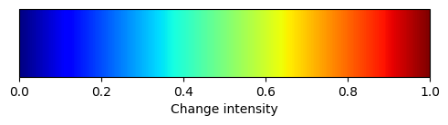
In tones of blue are shown stable areas, in red areas showing significant change.
Input
Input of the DISMapper services are multiple Optical Calibrated Datasets derived from Sentinel-2 L2A data and a pair of Auxiliary Datasets (Copernicus DEM and ESA World Cover). The service automatically retrieves all necessary Calibrated and Auxiliary Datasets by doing a search in the catalog with the values inserted by the user under the service parameters.
Note
Users do not have to specify the input Calibrated Datasets as well as the Auxiliary Datasets in the parameters of DISMapper.
Systematic mosaic of auxiliary data
Just after the creation of each activation workspace the ESA Charter Mapper systematically triggers the mosaic of multiple auxiliary data. For each auxiliary data a single band and an overview assets are offered to the users under an Auxiliary Dataset. In the activation workspace, Auxiliary Datasets are published together with Calibrated Datasets and are available in the Results list under the Datasets data context. The spatial extent of all auxiliary data available in the activation workspace is equal to the activation AOIs envelope, which consists of a buffered rectangle containing all activation AOIs. Such a rectangular area is the one used by the ESA Charter Mapper during the systematic mosaic of all auxiliary datasets.
From the multiple Auxiliary Datasets, DISMapper employs the ESA World cover and the Copernicus DEM ones.
Systematic ingestion and calibration of EO data
Once the activation workspace is created for a Landslide, Wildfire or Volcano charter activations and related AOIs are defined for the call, the ESA Charter Mapper systematically ingests and calibrates multiple Sentinel-2 L2A acquisitions to also prepare the input for on-demand processing with DISMapper.
In this systematic ingestion and calibration of Sentinel-2 L2A data the following criteria are taken:
-
Cloud coverage - only Sentinel-2 L2A acquisitions having cloud coverage <=75%.
-
Spatial coverage - only Sentinel-2 L2A acquisitions having image footprints contained within the spatial extent of auxiliary data.
-
Temporal coverage - only the Sentinel-2 L2A acquisitions that were acquired 365 days before and 30 days after the date of the event. As an example assuming 20230220 as date of the event, the Sentinel-2 L2A acquisitions that will be processed are the ones acquired from the 20220220 up to 20230322.
Parameters
The DISMapper service requires a specified number of mandatory and optional parameters. All service parameters are listed in the below Table 1.
| Parameter | Description | Required | Default value |
|---|---|---|---|
| Area of interest in WKT | Area of interest expressed in WKT. The AOI shall be contained within the common area between the footprint of a Sentinel-2 image and the extent of the auxiliary data. | YES | |
| Date of the event | Event date in the form YYYYMMDD |
YES | |
| Cloud coverage pre-event datasets | Cloud coverage threshold applied to the pre event products selection (0-25) | YES | 25 |
| Cloud coverage post-event datasets | Cloud coverage threshold applied to the post event products selection (0-75) | YES | 75 |
Table 1 - Service parameters for the DISMapper processor.
Area of interest in WKT
The first mandatory parameter defines the area of interest to be used by DISMapper. This geometry shall be expressed as a Well-Known Text value. The AOI shall be contained within the common area between the footprint of a Sentinel-2 image and the extent of input auxiliary datasets. If the AOI is intersecting more than 1 tile the processor takes the tile that has greater intersection with the AOI.
Warning
The input area of interest must be contained within the activation AOIs envelope and contained with the footprint of a Sentinel-2 L2A image.
Tip
In the definition of “Area of interest as Well Known Text” it is possible to apply as AOI the drawn polygon defined with the area filter. To do so, click on the button in the left side of the "Area of interest expressed as Well-known text" box and select the option AOI from the list. The platform will automatically fill the parameter value with the rectangular bounding box taken from the current search area in WKT format.
Date of the event
In the second mandatory parameter the user must insert the date of the event in the form YYYYMMDD (e.g. 20230220).
Maximum cloud coverage of pre-event datasets
In the third mandatory parameter the user shall insert the maximum cloud coverage percentage to be used by the service when selecting pre-event calibrated datasets. Default value is 25%, meaning that by default DISMapper will take only pre-event datasets having cloud coverage equal to or less than 25%. Inserted value shall be >0% or <=75%.
Maximum cloud coverage of post-event datasets
In the fourth mandatory parameter the user must insert the maximum cloud coverage percentage to be used by the service when selecting post-event calibrated datasets. Default value is 75%, meaning that by default DISMapper will take only pre-event datasets having cloud coverage equal to or less than 75%. Inserted value shall be >0% or <=75%.
Output
The DISMapper generates in output the following assets:
-
Change intensity single band
-
Change intensity overview
-
Change mask single band
-
Change mask single overview
DISMapper products specifications can be found in the below tables.
| Attribute | Value / description |
|---|---|
| Long Name | Change intensity RGB composite |
| Short Name | Overview_dismapper_change_intensity |
| Description | Visual product derived from the change intensity product [0,1] using a "BlueYellowRed" color map. In blue stable areas, in red areas showing significant change. |
| Data Type | UnSigned 8-bit Integer |
| Band | 4 |
| Format | COG |
| Projection | UTM |
| Valid Range | [1 - 255] |
| Fill Value | 0 |
| Attribute | Value / description |
|---|---|
| Long Name | Change intensity single band |
| Short Name | dismapper_change_intensity |
| Description | Change intensity from 0 to 1 |
| Data Type | Float64 |
| Band | 1 |
| Format | COG |
| Projection | UTM |
| Valid Range | [0 - 1] |
| Fill Value | N/A |
| Attribute | Value / description |
|---|---|
| Long Name | Change mask RGB composite |
| Short Name | Overview_dismapper_change_mask |
| Description | Visual product derived from the change mask product with transparency. Pixel in red shows detected changes |
| Data Type | UnSigned 8-bit Integer |
| Band | 4 |
| Format | COG |
| Projection | UTM |
| Valid Range | [1 - 255] |
| Fill Value | 0 |
| Attribute | Value / description |
|---|---|
| Long Name | Change mask single band |
| Short Name | dismapper_change_mask |
| Description | Mask derived from the binarization of the change intensity product. 0=no change 1=change |
| Data Type | 1-bit |
| Band | 1 |
| Format | COG |
| Projection | UTM |
| Valid Range | [0,1] |
| Fill Value | N/A |
Vectorize DISMapper change detection single band asset
DISMapper's binary change detection mask can be spatially filtered and / or converted to polygon using the FilterVectorize service.
To polygonize the dismapper_change_mask single band asset employ the FilterVectorize service in Vectorize mode by selecting only true values DN=1 (water).
In case a spatial filtering of DISMapper's output is needed, the FilterVectorize service can be used to further post-process the binary mask and remove small isolated clusters of pixels in the change detection mask (dismapper_change_mask). Thus to obtained further spatially filtered water extent vector employ the FilterVectorize service in the Filter and Vectorize mode.
Warning
Only the dismapper_change_mask single band asset can be used in the FilterVectorize on-demand service, being the only discrete raster produced by the DISMapper service.
-
Schlögel, R., Belabbes, S., Dell Oro, L., Déprez, A., Malet, J.-P., Belabbes, S., Oro, L.D., Malet, J.-P., Boivin, C., 2020. Disastrous landslides under changing forcing factors triggered end 2019 in West Kenya 19153. ↩